Geographic Information Systems (GIS) have evolved from specialized mapping tools to essential business solutions. Enterprises across industries increasingly adopt GIS to analyze spatial data, enhance decision-making, and improve operational efficiency.
According to the 2024 State of Spatial Report, nearly 70% of respondents confirmed performing spatial analysis via cloud-based tools and technologies. As spatial data becomes more accessible, organizations are investing heavily in GIS and advanced tools to extract immediate value and actionable insights for sophisticated business decision-making.
Let’s check out the top five benefits of GIS and how organizations are using it to strengthen their business processes.
1. Map-based Visualization
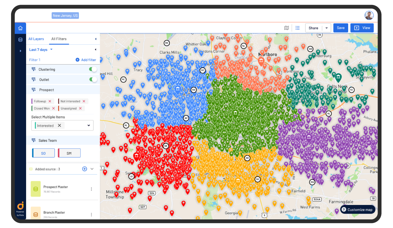
GIS makes it easy to understand complex data by turning it into interactive maps. Instead of looking at rows of numbers in spreadsheets, businesses can see patterns, relationships, and trends on a map. Leaders can plot their stores, branches, and outlets on a map and add multiple data layers to derive contextual analytics using a location intelligence platform.
For example, a retail company can use GIS to see where their customers are located, which stores have the highest sales, and which areas have untapped potential. With GIS and location intelligence, they can plan business expansion by analyzing foot traffic, customer demographics, and competitor locations. Instead of relying only on past sales data, they can see real-time insights and choose the best location.
Read More: Top GIS Trends for 2025
2. Strengthen Strategic Decisioning
95% of businesses believe that mapping and geospatial data are important in achieving desired results, says a BCG study. With robust AI tools and faster and easier access to them, business leaders can perform spatial analysis without requiring specialized expertise with the help of natural language processing (NLP). It empowers teams to get real-time insights, leading to better business decision-making.
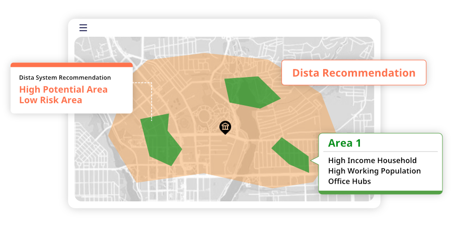
3. Accelerate Market Expansion
Sales and strategy leaders can use location intelligence platforms to strengthen business expansion strategies. Using several points of interest (PoI) variables, such as population density, income index, socio-demographic profile, consumer buying behavior, competition reach, etc., and pairing these data points with existing business variables gives a new dimension to expansion plans.
With a geospatial analytics platform like Dista, leaders can run multiple simulations for cluster and polygon analysis to gain deeper insights into location data.
Learn how a global pizza chain improved market penetration with GIS.
4. Enhance Geomarketing
GIS provides business leaders with geospatial insights by analyzing location and business data. These insights help create targeted geomarketing strategies and personalized location-based campaigns. Businesses can segment audiences based on buying behavior, income levels, and footfall traffic.
They can customize their marketing messages to match customer demographics, run campaign simulations in different area clusters, identify high-engagement zones, and offer localized discounts.
Businesses can use geodata to personalize loyalty programs, track sales trends, and anticipate customer needs. This data-driven approach strengthens customer relationships and boosts brand loyalty.
5. Improve Productivity
By automating repetitive and time-consuming tasks, like ingesting and cleaning large quantities of data, AI-powered tools will give leaders more time to focus on strategic work. Moreover, GIS enables businesses to allocate resources by providing insights into spatial data. Banks or retail companies can identify high-demand areas and optimize resources to cater to the footfall.
Final Thoughts
The convergence of AI with geospatial analytics signals a fundamental shift in how organizations process, analyze, and extract value from location data. Real-time geospatial analytics is becoming an essential aspect of business intelligence, giving rise to new use cases that will revolutionize how businesses approach everything from emergency response to network optimization.
Looking to use location insights to improve your business processes? Get in touch with us to get a free demo of our geospatial analytics platform in action.