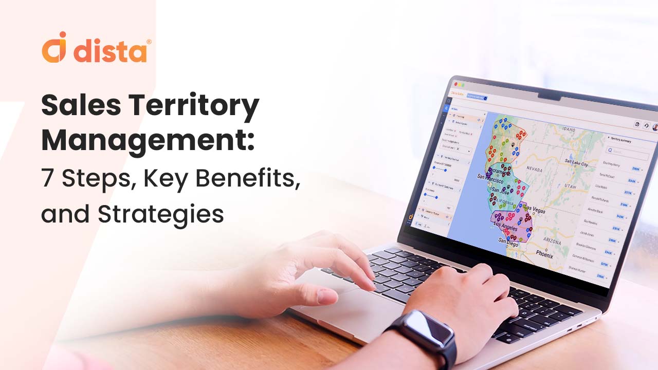
Geographic Information Systems (GIS) provide crucial spatial context to business decisions. Over the past few years, GIS has transformed the way businesses understand and utilize location data to make crucial decisions regarding expansion, workforce allocation, field force management, geomarketing, and more.
A Geospatial Professional Network (GPN) market survey highlights a sharp rise in GIS applications, including spatial analysis, map development, and data management. With its ability to enhance operational efficiency and streamline decision-making, GIS has become a must-have tool for enterprises aiming to stay ahead of the curve.
For businesses looking to gain a competitive edge, integrating intelligence from GIS is essential. Here’s a look at the top GIS trends expected to shape business strategies in 2026, helping organizations unlock new growth opportunities and improve strategic decision-making.
Also Read: 7 Ways GIS Can Improve Your Business
1. GIS Applications for BFSI
GIS enables financial institutions to identify and segment new markets using location-based data and demographic trends. It also supports strategic expansion, customer intelligence, and risk assessment through the following applications:
- Strategic Location Planning:
Determine optimal branch and ATM locations, assess competitor presence, and identify underserved areas as well as high-potential opportunities. - Customer Intelligence & Market Penetration:
Analyze economic activities and customer behaviors to pinpoint prospects, address specific customer needs, and expand market penetration. - Risk Assessment & Credit Analysis:
Map negative impact areas to better evaluate delinquency trends and strengthen customer credit profile assessments.
2. Emergence of GeoAI
GIS systems are rapidly evolving with the integration of AI, giving rise to GeoAI—that combines geospatial technology with AI and machine learning (ML) capabilities.
With the help of GeoAI, companies can:
- Identify patterns, predict trends, and automate processes within geospatial datasets, delivering insights that improve decision-making and support real-time problem-solving.
- Automate complex spatial data analysis, driving market insights, supply chain optimization, and strategic site selection.
- Enhance logistics route planning by integrating geospatial data with AI to optimize delivery routes in real time. This can be done by analyzing traffic, road closures, and weather to enable dynamic adjustments for faster deliveries, reduced fuel consumption, and lower costs.
Similarly, the BFSI sector can utilize GeoAI for advanced risk assessment, identification of untapped markets, and hyper-personalized services through location-based customer profiling.
3. Supply Chain Management
Leveraging GIS tools enables businesses to unlock the full potential of their supply chains. GIS analysis can:
- Provide spatial analysis for site selection
- Enable route optimization and logistics planning
- Improve inventory management with demand forecasting
- Enable risk assessment within supply chain networks
- Improve partner collaboration and stakeholder satisfaction
This helps businesses streamline their last mile deliveries, positively impacting the bottom line.
Read More: E-Commerce Firm Improves Supply Chain Network with Dista Insight
4. Cloud Computing and GIS
The shift toward cloud-based GIS solutions is rapidly gaining traction as organizations recognize the need for scalable, cost-effective tools to manage and analyze geospatial data.
With cloud integration, organizations can:
- Manage and analyze large volumes of spatial data without heavy infrastructure investments.
- Foster seamless collaboration among teams, enabling rapid decision-making based on real-time data analysis.
- Maintain secure, centralized control of spatial data within a dynamic, data-driven environment.
5. Internet of Things (IoT) and GIS in Urban Planning
GIS and IoT share a powerful synergy. GIS integrates spatial data with IoT devices that provide spatial context for businesses.
Take smart city planning, for instance.
- A plethora of interconnected IoT devices can monitor real-time traffic flow
- GIS analyzes this data and enables effective traffic management
- IoT devices can also monitor the air quality for a particular location
- GIS can then analyze this data to optimize infrastructure to lower carbon footprint.
Also Read: Location Intelligence: A Guide to Transform BFSI Organizations
Build Your Competitive Edge with GIS
According to a report, the global GIS market is projected to grow from $6.4 billion in 2020 to $13.6 billion by 2027, reflecting the increasing adoption of GIS across industries for decision-making and operational efficiency.
From the above applications it becomes increasingly clear that integrating GIS tools has become more than just a necessity for enterprises looking to gain a competitive advantage. The technology has a transformative impact that enhances business operational efficiency, cost-effectiveness, and helps in delivering superior customer experiences.
Want to explore how GIS can drive measurable impact for your business? Get in touch with our location intelligence experts today.